Weather station networks have been designed to provide real-time local weather information for a variety of uses, including pesticide spraying risk, burning, crop and pasture growth parameters and weather hazards.
Weather station networks are now found in Western Australia, South Australia, New South Wales and Victoria.The expansion of weather station networks has been enabled by development of new communication and data storage technology and, while they have often had different reasons for being set up, all can provide valuable local weather data for growers.
Key points:
- Improvements in communication and data storage technology have allowed the expansion and use of weather stations across the landscape.
- Australian weather station networks all started for different reasons but have many similarities and continue to expand the functions and types of data they gather.
- While weather station network data helps with spray planning, it is a legal requirement to measure and record meteorological data at the spray location during application.
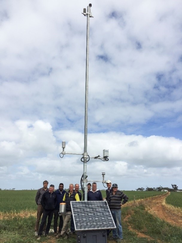 The team from the Mid-North Mesonet having successfully installed another weather station to help better measure local weather conditions for all agricultural enterprises in SA’s Mid North.
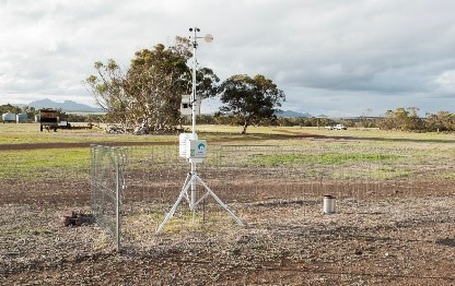
A typical weather station that makes up the 175 DPIRD stations delivering better local meteorological data to WA grain growers. This network also increases the accuracy of the Bureau of Meteorology’s weather predictions for south-western WA.
Mid North Mesonet – South Australia
South Australia’s first Mesonet consists of 40 weather stations in the Mid North, northern Adelaide Plains and northern Yorke Peninsula. The network provides growers with a much better idea of local meteorological conditions.
The impetus for this network has been crop damage, especially in the high-value grapevine areas, resulting from spray drift, with annual losses in value of production and reduced market access estimated at $178 million. (https://agex.org.au/project/mid-north-mesonet/)
Weather stations are located at specific sites 14 to 17 kilometres apart. These were selected after studying 10 years of weather patterns to give the best indicators of hazardous surface temperature inversions. The weather stations consist of a 10-metre tower measuring:
- Wind speed at 2m and 10m;
- Temperature at 1.25m, 3.2m and 10m; and
- Rainfall, relative humidity, soil moisture, solar radiation and barometric pressure.
The data is processed at each station on an ‘internet of things’ (IoT) gateway, where it is then sent to the server via the mobile phone network. The data is used to accurately calculate inversion risk and the grass fire index. The outputs are displayed online as 10-minute averages and is accessed through the website: https://midnorthmesonet.taindata.com/
The project has been made possible through funding by Primary Industries and Regions SA and is delivered by the Ag Excellence Alliance™.
Birchip Cropping Group shared data platform project
The Birchip Cropping Group (BCG) decided its members needed to be given experience in sharing data, and weather data was considered the best place to start.
At the time of writing BCG has 110 weather stations and 45 soil moisture probes with its members, who use the DataFarmer™ website https://www.datafarmer.com.au/ to store and access their weather data.
The first round of the project used the Wimmera-Mallee pipeline wifi for its network connection, while the second roll-out of weather stations and moisture probes used BaseStation® and Blue Node® https://smartelements.io/ to transfer data via the 3G network.
Currently the one-in-five BCG members who are involved in this program are those farmers are interested in tech solutions and looking for opportunities from technology.
Goanna Ag: a private NSW company
Goanna Ag has 70 weather stations between Lockhart and Moree in NSW on a 25km grid and claims to have 14 million hectares of farmland within the range of its network. The network was originally established to provide more localised weather data for on-farm decision-making.
The network is now used to calculate evapotranspiration, growth degree days and crop water use for a range of irrigated and dryland crops. In the Macquarie Valley, weather stations have been modified to alert growers to the presence of a temperature inversion.
The company has also introduced a low-power wide area network (LoRaWAN) supported by the National Narrowband Network Company (NNNCo) in cotton growing areas to enable growers to connect low-cost sensors such as soil probes, rain gauges, weather stations, and water and fuel tank monitors. This system is predicted to halve the cost of using the internet compared to the 3G-4G networks.
Goanna Ag is also working with Myriota, a South Australian company that uses low-orbit satellites to allow more growers and companies to connect their devices to the internet.
Western Australia
The oldest weather station network is in south-western Western Australia. This comprises 175 small weather stations interconnected by the Telstra™ mobile network and they link back to a central database run by the Department of Primary Industries and Regional Development (DPIRD). More recently, the data also feeds into the Bureau of Meteorology (BOM) and supports rainfall estimates coming from BOM radar stations over south-western Western Australia.
This program began in the early 1980s to gather data for wind erosion research at Jerramungup, Newdegate, Merredin and Mount Barker.
The early weather stations used magnetic tape recordings that had to be manually downloaded. As sensors and data recording developed, so did the system’s interconnectivity. What allowed the system to really take off was the development of the mobile phone network with mobile phone modems attached to loggers. Stations could be sited on farms and have the data transferred automatically to the DPIRD network.
Towards the end of 2010, additional funding was made available through a water use efficiency project and the following year off-the-shelf weather stations were bought and installed. More weather stations were added as funding became available, such as through the E-connected Grainbelt program.
As software improved, DPIRD hosted third-party data from Harvey Water™ (seven sites), and the Department of Biodiversity, Conservation and Attractions fire weather data from their fire towers above the forest canopy.
In 2015 links between BOM and DPIRD became stronger with the Wheatbelt Radars project, which resulted in three new Doppler radars being installed by the end of 2017.DPIRD weather data was transmitted to the BOM database to improve radar-derived rainfall estimates, supplementing short-term forecasting of weather in south-western Western Australia.
This information is currently being used by broadacre growers to help plan spraying operations, hay cutting and harvest, as well as monitoring weather conditions across the region.
As the system has grown, more groups see new uses for the data which is supported by improving technology. Smaller devices will be able to communicate back to the network, and where the mobile network is not available connections could be made through satellites.
What is a mesonet?
In meteorology, the term “mesoscale” refers to regional or local weather phenomena – including thunderstorms, rain bands and weather fronts – that range in size from a town up to a state such as Victoria.
Mesoscale observing systems sample a range of measurements in the lower atmosphere at spacings close enough to capture the detailed structure of mesoscale weather phenomena.
Therefore a “mesonet” is a network of weather stations spaced on a “mesoscale”.
Resources
DPIRD Weather – https://weather.agric.wa.gov.au/map
Mid-North Mesonet – https://agex.org.au/project/mid-north-mesonet/
Data Farmer® – https://www.datafarmer.com.au/
Goanna Ag – https://www.goannaag.com.au/
Article courtesy of Andrew Storrie – AGRONOMO


